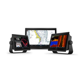
Garmin ECHOMAP Ultra 2 122sv Worldwide Basemap No Transducer
Garmin ECHOMAP Ultra 2 122sv 12" Chartplotter - Professional Marine Navigation with LiveScope Compatibility
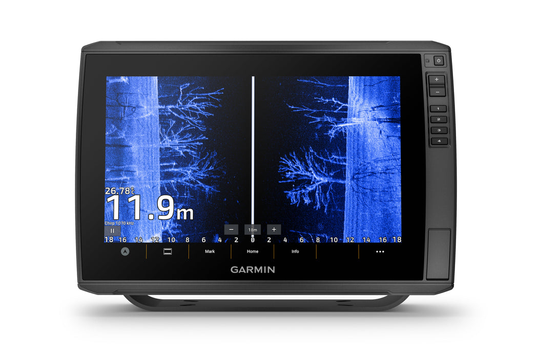
Experience precision navigation and advanced sonar capabilities with the Garmin ECHOMAP Ultra 2 122sv, featuring a brilliant 12.1" touchscreen display and cutting-edge marine electronics technology. This professional-grade chartplotter combines multi-constellation GPS positioning with comprehensive sonar systems, delivering unmatched situational awareness for serious anglers and navigators.
Built for demanding marine environments with IPX7 waterproof rating, this chartplotter offers seamless integration with Garmin's extensive marine ecosystem, including compatibility with the revolutionary LiveScope live-scanning sonar technology and wireless networking capabilities for multi-unit installations.
Professional Marine Navigation Features
Advanced Display Technology
- 12.1" WXGA IPS Touchscreen: 1280 x 800 resolution with sunlight-readable clarity
- Keyed Assist Navigation: Precision control in challenging conditions
- IPX7 Waterproof Rating: Complete protection against marine environments
- Versatile Mounting: Bail or flush mount installation options
Multi-Band GPS Precision
- Multi-Constellation Support: GPS, GLONASS, Galileo, and BeiDou satellites
- 10 Hz Update Rate: Ultra-smooth position tracking and navigation
- WAAS Capability: Enhanced accuracy for precise positioning
- Multi-Band Technology: Superior position accuracy in challenging environments
Comprehensive Sonar Systems
- 600-Watt Power Output: Deep-water penetration and target clarity
- CHIRP Traditional Sonar: 70/83/200 kHz frequencies with L/M/H CHIRP
- ClearVü Scanning: Photo-like underwater imagery (260/455/800/1000/1200 kHz)
- SideVü Technology: Wide-area fish and structure detection
- LiveScope Compatibility: Real-time live sonar capabilities (transducer sold separately)
- Panoptix Support: Complete underwater visualization system
Advanced Navigation Capabilities
- Extensive Memory: 5,000 waypoints, 50,000 track points, 100 routes
- Garmin Quickdraw Contours: Create custom depth contours in real-time
- Auto Guidance+: Intelligent route planning with depth awareness
- Chart Compatibility: Supports all major Garmin marine chart formats
Marine Network Integration
- Wireless Networking: Share sonar, waypoints, and routes between compatible units
- NMEA 2000/0183: Complete marine network compatibility
- Garmin Marine Network: Two large connector ports for system expansion
- ActiveCaptain App: Smartphone integration for enhanced functionality
Professional Installation Features
- Dual microSD Slots: Expandable chart storage and data backup
- 12-Pin Transducer Port: Advanced scanning sonar connectivity
- Robust Power System: 9-18 VDC input with 2.5A typical draw
- Complete Package: All mounting hardware and cables included
Technical Specifications
Physical Specifications
| Dimensions | 13.4" × 9.0" × 3.9" (34.1 × 22.9 × 9.8 cm) |
| Weight | 5.5 lbs (2.5 kg) |
| Display Size | 12.1" diagonal (30.7 cm) |
| Resolution | 1280 × 800 pixels WXGA IPS |
| Waterproof Rating | IPX7 |
Navigation & GPS
| GPS Systems | GPS, GLONASS, Galileo, BeiDou |
| Update Rate | 10 Hz |
| WAAS Support | Yes |
| Waypoints | 5,000 |
| Track Points | 50,000 |
| Routes | 100 |
Sonar Capabilities
| Power Output | 600 watts RMS |
| Traditional CHIRP | 70/83/200 kHz (L/M/H CHIRP) |
| ClearVü Frequencies | 260/455/800/1000/1200 kHz |
| SideVü Frequencies | 260/455/800/1000/1200 kHz |
| LiveScope Compatibility | Yes (transducer sold separately) |
Power & Connectivity
| Power Input | 9-18 VDC |
| Typical Current Draw | 2.5A at 12V |
| Maximum Power | 36W at 10V |
| NMEA Compatibility | 2000/0183 |
| Network Ports | 2 Garmin Marine Network (large) |
| Wireless | Wi-Fi, ANT+ |
Chart & Mapping Support
Supported Chart Formats
- BlueChart g3: Premium coastal and inland charts
- BlueChart g3 Vision: High-resolution satellite imagery
- LakeVü g3 Ultra: Detailed inland lake mapping
- Garmin Navionics+: Premium marine charts with daily updates
- Garmin Navionics Vision+: High-resolution relief shading and imagery
- Standard Mapping: Community-sourced depth data
- TOPO 100K: Topographic land mapping
Custom Mapping Features
- Garmin Quickdraw Contours: Create personalized depth maps
- Auto Guidance+: Intelligent route planning with obstacle awareness
- Community Sharing: Access millions of Quickdraw contours
Complete Installation Package
Included Components
- ECHOMAP Ultra 2 122sv chartplotter unit
- Power/data cable with marine-grade connectors
- Bail mount with quick-release cradle system
- Protective sun cover for display protection
- 8-pin to 12-pin transducer adapter cable
- Complete mounting hardware kit
- Comprehensive installation documentation
Ideal Applications
- Sport Fishing: Advanced sonar for fish finding and structure identification
- Commercial Navigation: Professional-grade GPS accuracy and reliability
- Recreational Boating: User-friendly interface with powerful capabilities
- Marine Survey: Precise positioning and custom chart creation
- Fleet Operations: Network integration and data sharing capabilities
Marine Industry Standards
- IPX7 Waterproof Rating: Complete protection against water immersion
- NMEA 2000/0183 Certified: Industry-standard marine network compatibility
- FCC Part 15 Compliant: Electromagnetic interference standards
- CE Marking: European conformity standards
- USCG Chart Standards: Compatible with official navigation requirements
Frequently Asked Questions
Does the ECHOMAP Ultra 2 122sv include a transducer?
No, this unit (010-02881-00) is sold without a transducer. It includes an 8-pin to 12-pin adapter cable for connecting compatible Garmin transducers. This allows you to select the specific transducer that best matches your fishing and navigation requirements.
Can this chartplotter connect wirelessly to other Garmin units?
Yes, the ECHOMAP Ultra 2 122sv can wirelessly network with other compatible ECHOMAP Ultra 2 or ECHOMAP UHD2 chartplotters. You can share sonar data, waypoints, and routes between connected units via one-to-one wireless connections.
What LiveScope transducers are compatible with this unit?
The ECHOMAP Ultra 2 122sv supports the full lineup of Garmin LiveScope transducers, including LiveScope, LiveScope XR, and LiveScope Plus systems. These transducers are sold separately and provide real-time, live-action sonar imagery of fish and structure.
Does this unit support custom chart creation?
Yes, the unit includes Garmin Quickdraw Contours technology, allowing you to create personalized depth contours in real-time. You can also access millions of community-shared Quickdraw contours and contribute your own data to help other boaters.
What is the difference between ClearVü and SideVü sonar?
ClearVü provides high-frequency down-imaging sonar that shows detailed images directly below your boat, ideal for identifying bottom structure and fish. SideVü scans to the left and right of your boat, covering wider areas to locate fish and structure away from your boat's path.
Can I use this chartplotter for both saltwater and freshwater applications?
Absolutely. The ECHOMAP Ultra 2 122sv is designed for universal marine use and supports both coastal/saltwater charts (BlueChart g3) and inland/freshwater mapping (LakeVü g3). The IPX7 waterproof rating ensures reliable operation in all marine environments.
Garmin ECHOMAP™ Ultra 2 122sv 12"" Chartplotters without Transducer
Model: 010-02881-00- SUPPORTS LIVESCOPE™ SONAR1 AND MORE
- WIRELESSLY NETWORK; SHARE SONAR, WAYPOINTS AND ROUTES2
- CAPTURE SCREEN RECORDINGS TO SHARE FISH CATCHES
- MULTI-BAND GPS FOR IMPROVED POSITION ACCURACY
With big, crisp, sunlight-readable touchscreen displays, these versatile chartplotters put a world of fishfinding capability at your fingertips. They’re available with built-in Garmin Navionics+™ mapping, and the transducer bundle adds Ultra High-Definition scanning sonars as well as CHIRP traditional sonar.
The ECHOMAP Ultra 2 series supports the full lineup of LiveScope live-scanning sonar products (transducers sold separately).
High-contrast vivid scanning sonar color palettes make it easier than ever to distinguish targets and structure.
Bring a fresh new look and feel to your chartplotter with optional Garmin Navionics Vision+™ premium mapping (sold separately), featuring high-resolution relief shading, satellite imagery and more.
If you have another compatible ECHOMAP Ultra 2 or ECHOMAP UHD2 chartplotter on your boat, you can wirelessly share information — such as sonar, waypoints and routes — with them.
LiveScope™ System sonar transducer sold separately Via one-to-one unit wireless connection only LiveScope sonar cannot be shared wirelessly between two ECHOMAP Ultra 2 or ECHOMAP UHD2 chartplotters Requires the ActiveCaptain app on your compatible smartphone paired to your ECHOMAP Ultra 2 series chartplotter
Specifications| General | |
| DIMENSION | 13.4"" x 9.0"" x 3.9"" (34.1 x 22.9 x 9.8 cm) |
| WEIGHT | 5.5 lbs (2.5 kg) |
| WATERPROOF | IPX7 |
| TOUCHSCREEN | Yes |
| DISPLAY TYPE | WXGA, IPS |
| DISPLAY SIZE | 10.3"" x 6.4""; 12.1"" diagonal (26.1 x 16.3 cm; 30.7 cm diagonal) |
| DISPLAY RESOLUTION | 1280 x 800 pixels |
| MOUNTING OPTIONS | Bail or flush |
| INPUT | Touchscreen with Keyed Assist |
| Maps & Memory | |
| ACCEPTS DATA CARDS | 2 microSD cards |
| WAYPOINTS | 5000 |
| TRACK POINTS | 50,000 |
| TRACKS | 50 saved tracks |
| NAVIGATION ROUTES | 100 |
| Sensors | |
| GPS | Yes |
| GLONASS | Yes |
| GALILEO | Yes |
| BEIDOU | Yes |
| HAS BUILT-IN RECEIVER | Yes |
| RECEIVER | 10 Hz |
| NMEA 2000 COMPATIBLE | Yes |
| NMEA 0183 COMPATIBLE | Yes |
| SUPPORTS WAAS | Yes |
| SUPPORTS MULTI-BAND, MULTI-CONSTELLATION GPS | Yes |
| Built-in Maps | |
| BUILT-IN AUTO GUIDANCE+ | Yes |
| GARMIN NAVIONICS+ INLAND & COASTAL | No |
| TIDE TABLES | No |
| Optional Map Support | |
| BLUECHART G3 | Yes |
| BLUECHART G3 VISION | Yes |
| LAKEVü G3 | Yes |
| LAKEVü G3 ULTRA | Yes |
| GARMIN NAVIONICS+™ | Yes |
| GARMIN NAVIONICS VISION+™ | Yes |
| TOPO 100K | Yes |
| STANDARD MAPPING | Yes |
| GARMIN QUICKDRAW CONTOURS | Yes |
| Electrical Features | |
| POWER INPUT | 9 to 18 Vdc |
| TYPICAL CURRENT DRAW AT 12 VDC | 2.5 A |
| MAXIMUM CURRENT DRAW AT 12 VDC | 5.0 A |
| MAXIMUM POWER USAGE AT 10 VDC | 36 W |
| Connections | |
| NMEA 2000® PORTS | 1 |
| GARMIN MARINE NETWORK PORTS | 2 (large connector) |
| 12-PIN TRANSDUCER PORTS | 12-pin scanning sonar |
| ANT+ (CONNECTIVITY) | Yes |
| GARMIN WI-FI NETWORK (LOCAL CONNECTION) | Yes |
| Sonar Features | |
| DISPLAYS SONAR | Yes |
| POWER OUTPUT | 600 watt |
| TRADITIONAL SONAR (DUAL FREQUENCY/BEAM) | built-in (single channel CHIRP, 70/83/200 kHz, L, M, H CHIRP) |
| CLEARVü | built-in 260/455/800/1000/1200 kHz |
| SIDEVü | built-in 260/455/800/1000/1200 kHz |
| PANOPTIX™ SONAR | Yes |
| LIVESCOPE | Yes |
What's in the Box:
- ECHOMAP Ultra 122sv
- Power/data cable
- Bail mount with quick release cradle
- Protective sun cover
- 8-pin transducer to 12-pin sounder adapter cable
- Hardware
- Documentation
!!!!----
PRODUCT ID: 1003609
SKU: NVN-1003609
CSKU: CWR-1003609
REWRITE: 1014720-garmin-echomap-ultra-2-122sv-worldwide-basemap
MPN: 010-02881-00
UPC: 753759325534
ASIN:
WSKU: GAR0100288100
SSKU:
KSKU:
GSKU:
MSKU:
LSKU:
NAME: Garmin ECHOMAP Ultra 2 122sv Worldwide Basemap No Transducer
NAME_EX:
PTITLE: Garmin ECHOMAP Ultra 2 122sv Worldwide Basemap No Transducer
TYPE: Marine Navigation & Instruments | GPS - Chartplotters
VENDOR: Garmin
Google Category: ELECTRONICS > MARINE ELECTRONICS > MARINE CHARTPLOTTERS & GPS
Amazon Category:
Amazon Title:
Google Title:
Amazon Category:
Gtags:
GSpecs: